The BetaNYC Civic Innovation Lab has recently launched FloodGen (floodgen.beta.nyc), a flood advocacy tool that uses generative AI to visualize photorealistic images of potential flood scenarios. Positioned as an advocacy tool that reaches beyond the limits of traditional aerial maps, FloodGen is designed to raise awareness, support community preparedness, and support local government’s resilience strategies.
Today, 1.3 million New York City residents live within or directly adjacent to the floodplain.1 Flood damage is expensive, extensive, and often predictable. Maps of projected flooding are helpful planning tools, but aerial views distance viewers from the potentially devastating impacts of flooding. If we show the reality of projected flooding through photorealistic imagery, could people be more prepared?
What is FloodGen?
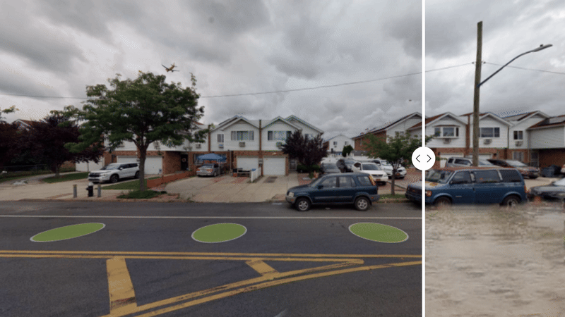
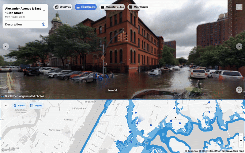
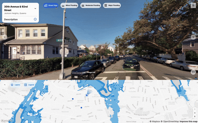
FloodGen is an interactive website that connects mapped flood risk areas with AI generated imagery that visualizes these potential flood scenarios more tangibly. Ten flood prone neighborhoods throughout the five boroughs of NYC were selected as case studies to demonstrate the potential of pairing photorealistic street view images of projected flooding. These case study sites were selected with the consideration of a spatial analysis framework that frames the natural hazard – coastal and stormwater flooding, the vulnerability of people impacted – disadvantaged communities and hurricane evacuation zones, and people’s exposure to nearby points of interest, including transit, public housing, hospitals, commercial areas, schools, and libraries.
We hope that FloodGen can equip advocacy groups with accessible generative flood imagery in a no-code interface to support their community flooding initiatives. Projected flood imagery from FloodGen can be integrated within community engagement strategies to:
- raise awareness for communities who have not yet experienced flooding
- create evidence for communities seeking resilience funding and projects
- respond to resilience advocacy efforts by municipal government agents and decision makers
Explore the FloodGen map and AI generated flood images at: floodgen.beta.nyc!
How does FloodGen work?
FloodGen implements a generative artificial intelligence technology called CycleGAN to transform normal street view images to depict projected flood scenarios. The BetaNYC Civic Innovation Lab team customized this algorithm to better align with our advocacy goals, improving the visualization of specific flooding heights and varied street elevation points to create more accurate depictions of the NYC urban environment. Users can toggle between views of various flood thresholds: normal street view (no flooding), minor flooding (less than 0.4 inches), moderate flooding (0.4 – 12 inches), and major flooding (greater than 12 inches). The FloodGen model is open-source, and more information about our methodology can be accessed on the BetaNYC GitHub repository, floodgen-methodology.
To mitigate any potential misinformation or misuse of information with the use of AI, our team has implemented some helpful tips for users to identify imagery that uses AI generated technology. All AI generated images featured on FloodGen have been identified with a FloodGen logo, located in the bottom-right corner. Additionally, the surreal quality of these AI generated images are intended to convey a level of photorealism to instill a sense of urgency around flooding as an issue, but are not intended to inspire panic. Some of these surreal qualities include: sometimes clear skies, calm water that is free of debris, and distortion where water surfaces meet objects in the foreground. FloodGen imagery does not predict future events, and these images are not intended to falsely portray historic flood events.
What’s next for FloodGen?
We hope that FloodGen can empower community engagement strategies to raise awareness for communities that have not yet experienced flooding, to create evidence for communities seeking resilience improvements, and to support municipal government agents and decision makers in responding to resilience advocacy efforts.
Moving forward, the BetaNYC Civic Innovation Lab is actively seeking partnerships! Through collaboration with community advocates and research partners, FloodGen can become an incredibly impactful tool. We hope to partner with advocates to support flood resilience and with researchers to further improve FloodGen’s image generator and interactive tool. If you are curious to learn more about FloodGen, think FloodGen could benefit your community, or are interested in future research collaboration, please fill out the FloodGen Partnership Interest Form. We would love to get in touch and connecting about potential partnerships to further the conversation!
Explore FloodGen at floodgen.beta.nyc !
Reference(s)
- Rebuild by Design. “Who lives in the floodplain in the year 2100?” https://secure-web.cisco.com/1hSWDIBpZI0J80qokJow0zXGnyiF7pKk03k7WLIqkJaIgPcyAj8d3MemVToDXHwW2leY5e_0fkl_6NjqKZkbilSOcKKk9-MjstJdRlMcrAjuNCWWQDUjlWBXUr3zw7NBEWdvlwNEiG05dtADN26ArsYl8DG99VRU4rUWZNR3s_BMSfFIGlQ7kT_hpZZN7ZfSVTAZ44jLO6bOTMaa4gcSig92-WnpQjrlA6zN9Inqwj0rTjuyVXbwUVYq3lEROWIae/https%3A%2F%2Frebuildbydesign.org%2Fwho-lives-in-nycs-floodplain%2F ↩︎